
Monday Morning Weather Blog
We're starting this morning with a mix of sunshine and clouds. We had a great sunrise over Hartford!
Stream Connecticut News for free, 24/7, wherever you are.

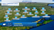
We'll see a little more cloud cover in the afternoon with high temps in the upper 60s to lower 70s.
Get top local Connecticut stories delivered to you every morning with the News Headlines newsletter.
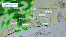
Tuesday will warm a little more as humidity starts to gradually increase. As a result, a few rain showers will be possible by Tuesday afternoon and evening.
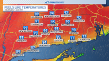
The big weather story this week is the large warm-up expected. Highs will be back in the 80s by Wednesday before warming to near 90 on Thursday! Dew point temperatures should warm into the 70s, so a heat index near the mid-90s is possible by Thursday ahead of storm chances.
A storm system is expected to sweep across the east coast on Thursday. It's still several days out, but if this system can roll through Connecticut during the afternoon and evening hours, it could create some severe weather close by. Stay tuned for updates.

Even after Thursday's rain chance, above average temperatures are expected through the second half of June. The official first day of summer is on Friday, which is also the longest day of the year.
